English| EUR
Suggested for you
More currencies
Choose a language
Purnululu National Park lies deep in Western Australia's Kimberley region, a landscape where distance is measured in fuel tanks and daylight hours. The journey from Broome to the Bungle Bungle Range spans remote sealed highways, corrugated unsealed roads, and stretches where mobile coverage vanishes for hundreds of kilometres. Understanding the distance and route options determines whether you arrive safely and on schedule.
Quick answer
The Broome to Bungle Bungles distance is approximately 1,050 kilometres by road via the Great Northern Highway and Spring Creek Track, typically requiring 13 to 15 hours of driving split across two days. The final 53-kilometre access road into Purnululu National Park is unsealed and demands a high-clearance four-wheel-drive vehicle. Alternatively, charter flights from Broome cover the distance in around 90 minutes, landing at airstrips near the park entrance.
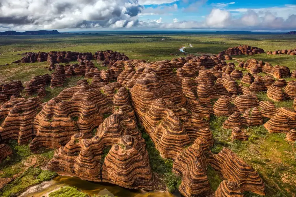
The beehive domes of the Bungle Bungle Range rise from sandstone carved over 350 million years, yet their remoteness kept them unknown to the wider world until aerial surveys in the 1980s. That same remoteness shapes every visitor's approach today—Purnululu National Park sits 300 kilometres south of Kununurra and more than 1,000 kilometres east of Broome, connected only by highways built to move cattle and freight across the Kimberley. The journey from Broome measures roughly 1,050 kilometres, a two-day drive that traces the Great Northern Highway through Derby, Fitzroy Crossing, and Halls Creek before turning north onto the unsealed Spring Creek Track. Most travellers break the trip at Halls Creek, 140 kilometres south of the park turnoff, where fuel and supplies are available. The final 53 kilometres from the highway to the park boundary follow Spring Creek Track, a corrugated unsealed road passable only by four-wheel-drive vehicles with high ground clearance. Conventional sedans and two-wheel-drive rentals cannot legally or safely access the park, and roadside assistance does not operate beyond the sealed highway. The track surface deteriorates after rain, and the park closes entirely during the wet season from December through March when flash flooding renders the route impassable. Travellers who underestimate the Broome to Bungle Bungles distance or the unsealed section's demands risk mechanical failure in country where the nearest tow service operates hours away. Flight options compress the distance into 90 minutes of air time, with charter operators departing Broome for airstrips at Bellburn or the park's ranger station. These services eliminate the multi-day drive and unsealed road concerns, though they require advance booking and operate on limited schedules. The aerial approach also reveals the Bungle Bungle Range's scale and isolation—orange-and-black striped domes stretching across 450,000 hectares of spinifex and gorge country, bound by the Ord River system to the north and the Tanami Desert fringe to the south. On the ground, that same isolation means preparation extends beyond distance calculations to fuel reserves, water supply, and contingency plans for breakdowns or road closures. The park itself operates on schedules shaped by access constraints. Purnululu National Park opens daily from 08:00 to 16:00 between April and November, with a standard vehicle entry fee of 15 AUD per day. The ranger station at Spring Creek Track, Western Australia 6770, holds updated road condition reports and can be reached at +61 8 9168 4295. Visitors arriving by road should plan for the 08:00 to 10:00 window to reach walking trails during cooler morning hours before midday temperatures exceed 35 degrees Celsius.
“The beehive domes of the Bungle Bungle Range rise from sandstone carved over 350 million years, yet their remoteness kept them unknown to the wider world until aerial surveys in the 1980s.”
The Bungle Bungle Range is located within Purnululu National Park, approximately 1,000 kilometers by road from Broome. While self-driving is possible, direct flight options provide the most efficient travel method across the Kimberley region.
Great Northern Highway and Spring Creek Track
Direct charter from Broome to Purnululu
The Spring Creek Track is a four-wheel-drive access road; visitors should utilize the 08:00–10:00 arrival window to avoid mid-day heat and ensure safe transit.
Purnululu National Park maintains consistent operating hours throughout the week to support visitors traveling to the Bungle Bungle Range.
Remote Kimberley travel requires advance preparation for long-distance driving, limited services, and extreme conditions.
Everything you need to know about broome to bungle bungles distance
The driving route from Broome to Purnululu National Park covers over 1,000 kilometres along the Great Northern Highway. From the highway turn-off, you must then navigate the 53km Spring Creek Track to reach the park entrance.
Driving the full route can take many hours depending on your pace and stops. The final 53km section via the Spring Creek Track typically requires 1.5 to 3 hours due to its rugged, unsealed nature and creek crossings.
No, the Spring Creek Track is strictly for high-clearance 4WD vehicles and single-axle off-road trailers. You should leave standard vehicles and dual-axle caravans at the designated storage areas near the Great Northern Highway.
Yes, several operators offer scenic flight tours that cover the broome to bungle bungles distance efficiently. These flights provide aerial views of the Kimberley landscape and often include a guided walking tour once you land at the remote Bellburn airstrip.
Taking a scenic flight is the most efficient way to manage the long broome to bungle bungles distance if you are short on time. Many full-day tours depart Broome in the morning, include a flight over the Kimberley and a guided hike, and return in the evening.
You must pay a standard park entry fee of 15 AUD per vehicle, per day to enter Purnululu National Park. This fee applies to all visitors accessing the park, regardless of whether you arrive by 4WD or air tour.